- Trip Overview
- Trip Itinerary
- Similar Tours
What's included
- Unlimited bottled water
- Visa arrangements
11 Days Kilimanjaro Northern Circuit Route,
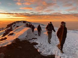
The Northern Circuit Route is the longest and most scenic route on Mount Kilimanjaro, offering unmatched views of the mountain from nearly every angle. Spanning 11 days, this route provides the highest success rate due to its gradual acclimatization profile. It’s ideal for adventurers looking to fully immerse themselves in the beauty of Kilimanjaro while increasing their chances of a safe and successful summit.
This lesser-trodden trail circles around the northern slopes, away from the busier southern routes, ensuring a quiet, remote, and truly unique trekking experience. The route combines parts of the Lemosho Route with the northern circuit trail, finishing via the Rongai or Marangu descent path.
📌 Tour Highlights
-
Longest route = best acclimatization = highest success rate
-
Remote, quiet trails with fewer climbers
-
Panoramic views from all sides of the mountain
-
Diverse ecosystems from rainforest to alpine desert
-
Chance to spot wildlife on the lower slopes

You may read and write some reviews for us from Safari Bookings.
Book Cheap Kilimanjaro Climb Northern circuit Route With KILINGE ADVENTURES
- Day 1
- Day 2
- Day 3
- Day 4
- Day 5
- Day 6
- Day 7
- Day 8
- Day 9
- Day 10
- Day 11
Londorossi Gate to Mti Mkubwa (Big Tree Camp)
Start Elevation: ~2,100 m
End Elevation: ~2,650 m
Distance: ~6 km
Hiking Time: 3–4 hours
Habitat: Montane forest
Highlights: A scenic forest trail with a chance to spot colobus monkeys.
Mti Mkubwa to Shira One Camp
Start Elevation: ~2,650 m
End Elevation: ~3,610 m
Distance: ~8 km
Hiking Time: 5–6 hours
Habitat: Moorland
Highlights: Emergence into the Shira Plateau with expansive views of Kibo.
Acclimatization Day – Hike to Cathedral Point and back to Shira One
Elevation Gain: ~400 m (Cathedral Point ~4,000 m)
Distance: ~6–7 km round trip
Hiking Time: 3–4 hours
Highlights: An important acclimatization hike offering stunning views over the plateau.
Shira One to Shira Two Camp
Start Elevation: ~3,610 m
End Elevation: ~3,850 m
Distance: ~7 km
Hiking Time: 4–5 hours
Habitat: Moorland
Highlights: Cross the vast and surreal Shira Plateau with panoramic views.
Acclimatization Hike to Lava Tower and return to Shira Two Camp
Max Elevation: ~4,630 m (Lava Tower)
End Elevation: ~3,850 m (Shira Two)
Distance: ~9–10 km round trip
Hiking Time: 5–6 hours
Highlights: Key acclimatization day reaching high altitude and returning to sleep low.
Shira Two to Moir Hut
Start Elevation: ~3,850 m
End Elevation: ~4,200 m
Distance: ~10 km
Hiking Time: 5–6 hours
Habitat: Alpine desert
Highlights: Remote and peaceful camp at the base of Lent Hills.
Moir Hut to Buffalo Camp via Lent Hills
Start Elevation: ~4,200 m
End Elevation: ~4,020 m
Distance: ~12 km
Hiking Time: 6–7 hours
Highlights: Optional hike up Lent Hills (~4,375 m), then trek across the northern slopes.
Buffalo Camp to Third Cave Camp
Start Elevation: ~4,020 m
End Elevation: ~3,870 m
Distance: ~8 km
Hiking Time: 4–5 hours
Highlights: Easy hiking day across scenic alpine zones with fewer crowds.
Third Cave Camp to School Hut (Base Camp)
Start Elevation: ~3,870 m
End Elevation: ~4,750 m
Distance: ~5 km
Hiking Time: 4–5 hours
Highlights: Final camp before summit push; rest and prepare.
Summit Day – School Hut to Uhuru Peak and down to Millennium Camp
Start Elevation: ~4,750 m
Summit Elevation: 5,895 m (Uhuru Peak)
End Elevation: ~3,820 m
Distance: ~15–16 km
Hiking Time: 12–15 hours
Highlights: Night hike to Gilman’s Point and Uhuru Peak. Celebrate at the top of Africa, then descend to rest.
Millennium Camp to Mweka Gate – Transfer to Moshi/Arusha
Start Elevation: ~3,820 m
End Elevation: ~1,650 m
Distance: ~10 km
Hiking Time: 4–5 hours
Habitat: Rainforest
Highlights: Final descent through lush forest. Certificate at the gate!


